Multi-day walks staying in overnight huts allow you to experience the Aosta Valley to the full.
For serious walkers, multi-day walks staying in overnight huts are a wonderful way to explore this spectacular alpine environment. Walkers will be surrounded by dramatic peaks of over 3000 metres. The most popular are Alta Via no 1 which goes from Gressoney Saint Jean to Courmayeur at the foot of Mont Blanc and Alta Via no 2 which approaches Courmayeur from Champorcher passing through the Mont Avic Regional Park and the Gran Paradiso National Park.
Trekking Map (Treks other than those outlined below)
Local Contacts and Trekking Tips
Trekking Trails
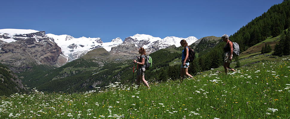
Alta Via Trail 1
Alta Via Trail 1, known as the Alta Via dei Giganti, or “the giants’ trail”, is a trekking route through incomparable scenery, across the foothills of some of the highest peaks in Europe such as Monte Rosa, the Matterhorn and Mont Blanc.
This itinerary offers, alongside some superb examples of natural alpine architecture (including the elegant pyramid of the Matterhorn), matchless specimens of rural architecture that are inextricably linked with the life of the alpine pasturelands, such as the traditional Walser buildings in the Gressoney Valley and the upper reaches of the Ayas Valley. Tracing its path through the mountains to the left of the River Dora Baltea, Alta Via Trail 1 can be walked by anyone since it follows well-marked footpaths, with an average width of 80 cm, that are fully signposted.
The route leads from Donnas to Courmayeur, with 17 daily stages that require 3-5 hours walking time each, offering stopping points for all needs: camping sites, huts, refuges, hotels and hostels. The route can be walked in the summer months and crosses medium and high altitude mountain areas, through meadows and pasturelands, woodlands and rocky outcrops, maintaining an average altitude of around 2,000 m. and often touching almost 3,000 m.
The trekker who is an experienced mountain walker will be able to walk its whole length, while those who wish to try out its footpaths as a first experience will also be able to walk the short, lower altitude stretches.
For further information click here
Alta Via Trail 2
Alta Via Trail 2, known as the nature Trail, is a trekking trail of exceptional natural interest. A large part of its route passes through the Gran Paradiso National Park and the Mont Avic Regional Park.
This route passes through wild areas of magnificent landscapes where numerous examples of alpine flora and fauna are to be found, including some of the rarest species, as well as through village areas where it is possible to explore the ancient origins of Aosta Valley traditions and crafts. Crossing the mountains to the right of the River Dora Baltea, Alta Via Trail 2 is accessible to everyone since it follows well-marked footpaths, with an average width of around 80 cm., and is entirely sign-posted.
The route leads from Courmayeur to Donnas, with 14 daily stages which require 3-5 hours walking time each, offering various stopping points: camping sites, huts, refuges, hotels and hostels. The route can be walked in the summer months and crosses medium and high altitude mountain areas, through meadows, pasturelands, woodlands and rocky outcrops, maintaining an average altitude of around 2,000 m. and sometimes reaching 3,000 m.
The trekker who is used to mountain walking will be able to walk along its whole length, while those who are looking forward to trying footpath walking for the first time will also be able to follow some of the short, lower altitude stretches.
For further information click here
Cammino Balteo: a timeless journey
A new hiking trail that crosses the entire Aosta Valley and takes you a journey through time.
From Pont-Saint-Martin to Morgex, return, there are a total of 23 stages from 4 – 6 hours each, 350 km/217 miles of hiking across 46 towns! One particularity of the Cammino Balteo is that almost the entire route is located in medium mountains ranging from 500m and 1,900m in altitude, therefore making the route accessible throughout the year, summer and winter and for all levels and families! You can choose to go through the entire loop or simply do certain stages during the day.
Much more than a hike, the Cammino Balteo is a journey through time, where the history of man has left the most obvious traces of his passage. A journey in the wake of Roman and medieval times, but also an immersion in nature: lakes, waterfalls, nature reserves and wooded areas. A walk to discover the architecture of the villages and the local traditions still alive and rooted, meeting the rural landscapes, pastures, vines, cultures, mills, cellars and cheese factories. Crossing authentic villages, meeting and sharing with their inhabitants. There are options to visit the castles, or taste local products along the way.
Via Francigena
Walking along the Via Francigena in the Aosta Valley means strolling through ancient villages and splendid castles, impressive churches and important vestiges of the Roman era, all against the backdrop of the Alps.
Along this route you will also find numerous vineyards boasting prestigious wines, and areas acclaimed for the local PDO produce such as the ham “prosciutto di Bosses” and the lard “lardo di Arnad”.
The route is divided into five stages starting at the Great Saint-Bernard pass, at an altitude of 2,450 metres, on Swiss territory; the path takes you down along the Great Saint-Bernard valley in the direction of Aosta (580 m), the region’s capital and city offering a wealth of history and testimonies to the past, then moving on along the central valley to Pont-Saint-Martin where you leave the Aosta Valley to enter the Piedmont region.
It is advisable to take the stage no. 1 in summer (or in the absence of snow at the pass) while those along the central valley are suitable for every season, even for a 2 or 3-day trek to discover the region.